Send your concerns, pictures, and trouble spots to Mark »
Facebook »

Old Keene Mill Road, Springfield

Looking west on Old Keene Mill Road at Carrleigh Parkway
Distance not connected: 150 feet
Across the street from Springfield Golf & Country Club – another disappearing act! Apparently no one walks from Irving Middle School to the shopping centers at Rolling Road. Nothing but trees. Nice crosswalk and signal but are pedestrians supposed to use the road shoulder?

Looking east on Old Keene Mill Roadfrom Prince of Peace Lutheran Church

Little River Turnpike, Annandale

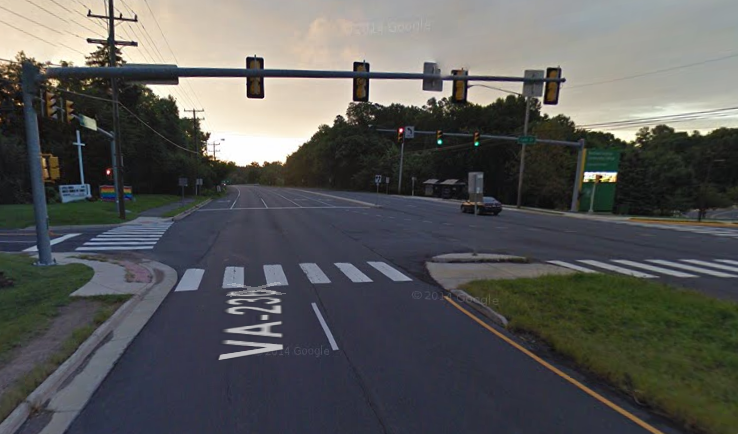
Looking east on VA 236 at entrance to NOVA
Distance not connected: 200 feet
Well, there is a crosswalk from Northern Virginia Community College (a.k.a. NOVA) to the north side of Little River Turnpike. And the path on that side of the street provides a start for Winterset neighborhood residents before ... POOF! ... the path disappears under heavy vegetation (see below). BTW – There's no sidewalk on the south side of VA 236 and note dirt path heading west (above on left).

Until Fairfax County or the homeowner clears the overgrowth you'll need a machete to hack through.

Looking east on VA 236 before Winterset Drive

Arlington Boulevard, Fairfax

Eastbound on Arlington Boulevard at Pickett Road
Distance not connected: 500 feet
Walkers hoofing it from the businesses and apartments at Fairfax Circle have to navigate an unpaved shoulder on Arlington Boulevard (U.S. Route 50) to a worn footpath (shown below on the right) as they make way to apartments, retirement communities, and the Merritt Academy. The footpath proves that there's plenty of pedestrian traffic to warrant a sidewalk.

Eastbound on Arlington Boulevard at Stonehurst Drive

Maple Avenue, Fairfax

Southbound at 4100 block of Maple Avenue

Distance not connected: 500 feet
Sidewalks that connect adjoining neighborhoods end abruptly – forcing pedestrians onto a narrow, tree-lined road with a blind hill that's heavily traveled by cut-through traffic to avoid speed bumps on Burke Station Road and the associated signal at Main Street in Fairfax City.

Northbound at 4100 block of Maple Avenue

Burke Road, Burke

Southbound on Burke Road near Burke Lake Road

Here's another episode of "What Were They Thinking?"

The sidewalk on the right continues northbound on Burke Road while left ends abruptly near the stormdrain opening (lower left). Circled in yellow is a staircase that descends into the Raintree community near Lake Braddock. While pedestrians should walk to the crosswalk at the signal at Burke Lake Road, the deadend sidewalk encourages them to stay on the east side of the street or cross immediately without a crosswalk at a point on northbound Burke Road where traffic is heading downhill. A dangerous mix.

Southampton Drive, Springfield

Looking west on Braddock Road at Southampton Drive

Though not a disconnected sidewalk issue, this intersection of Southampton Drive at Braddock Road poses dangers to pedestrians. Trust me: I encountered it last night.

Turning from northbound Southampton onto westbound Braddock (from the right in the picture above) last night, there was traffic stopped at the signal to my right and left, a car heading toward me on southbound Southampton from the Canterbury Woods neighborhood into the Kings Park neighborhood, and a pedestrian in the near crosswalk. What I didn't see were two darkly dressed pedestrians in the far crosswalk, blocked from view by the oncoming car. Fortunately I stopped short before entering the crosswalk.

This is a difficult intersection for walkers: eight lanes of road, a center turning lane, and a median. Making it worse is the lack of nighttime illumination: there is only one streetlight (in red circle). And it's a busy intersection: note the Metrobus stop circled in blue. With a traffic signal support on each corner and electrical power to each, there's great potential for safety enhancements.

Olley Lane, Fairfax

Southbound Olley Lane at Shari Drive

Distance not connected: 500 feet
Yes, there's a continuous length of sidewalk on the east side of Olley Lane; the current poorly maintained path on the west side ends just past the Metro stop (top picture on right). But notice that there's no way to get to the bus stop from Chestnut Knolls Drive (on left in bottom picture) unless you cross Olley Lane twice – each time without a designated crosswalk. And that's what's expected of W.T.Woodson High pyramid students.

Northbound Olley Lane at Chestnut Knolls Drive

Cedar Lane, Vienna/Merrifield

Northbound at 2900 block of Cedar Lane

Distance not connected: 1,000 feet
Heading north from Lee Highway in Merrifield, walkers transition to a grass and dirt path in making their way toward Cedar Park and beyond. Gotta love the pedestrian barrier on the other end. BTW there's no sidewalk at all on Cedar Lane between Lee Highway and Arlington Boulevard.

Southbound at 2900 block of Cedar Lane